
A few times a year, the sky over Milan clears up so well that the mountains appear to be just a few kilometers away. On those days, I can see their colors and their rock formations in great detail. Yesterday was such a day. Today was such a day. It was the perfect setting for a ride that had been in the making for long.
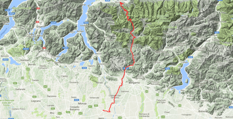
The Valtellina in Lombardy has access to many famous mountains. The Splügen, the Stelvio, the Gavia, the Mortirolo, the Bernina (from Tirano) – that’s the ground of many epic cycling adventures on a very small territory. And then there are some less well-known, but equally interesting climbs. The Agueglio comes to mind, for instance, which starts at Lago di Como and ends at Lago di Como and along much of its route offers breathtaking views on the lake. And there is the Passo San Marco, which is just shy of 2,000m. That’s maybe one reason it’s not so popular. The other one that it leads from almost at the lake to Bergamo – it might just not match with the typical trajectory of multi-day bike trips. And, finally, it’s a bit isolated, with no other significant mountain very close on either side, so that it does not fit the usual story-line of the mountain stages of the Giro d’Italia. So, less media exposure: less fame.

However, the climb is beautiful. It’s very rare that one can see where the climb leads up to from very early on, but coming from the Northern side (Morbegno), that actually works great. Look out for the electricity masts – where they vanish behind the mountains, that’s the peak. The Northern side also has the advantage to have lots of shadow if one starts rather early. It’s initially less intense than Splügen, Bernina, and the Mortirolo, but also not too easy. In the steep mid section, it gets a bit nonrhythmic before a short flat stint. In that mid section, the peak disappears from sight, but instead it’s still easy to look back to the villages that have been left behind. They are cute, by the way. Finally, the mountains disappear, and a landscape takes over that is just beautiful in the way how it is rough/edgy and soft/tender at the same time. And being able to look that far in the distance… it’s maybe not 2,000m, but it felt like as much like the top of the World as the Stelvio and the Gavia did. I have been on few peaks that offered such a massive all-around-in-the-distance high-alpine panorama.


Going down towards South, 13 hairpin turns make for a fun descent and still offer more views in a wide range of directions. Things flatten out a bit in Mezzoldo, which like many of the villages on the Southern side was surprisingly lively. Maybe because it’s at the peak of Summer – but at most other places in Lombardy this has actually decreased crowd sizes. And traffic. But traffic was also a charming nothing here in Val Brembana.
Even though that doesn’t really matter for much of the valley. In the 1960s, a local train line closed when tourism into the villages found other, hipper destinations. A silent witness of that loss of significance is also the Grand Hotel in San Pellegrino. Yes, that San Pellegrino. It’s a gigantic ruin. Though, it seems that renovation works have resumed. I saw that things are happening compared to my last visit a few months ago. That would be fabulous.
Often, the closure of a valley’s rail line does impede modern tourism, but in the Val Brembana, the opposite is the case. Those guys have been smart enough to turn the entire rail track between Piazza Brembana and Zogno into a beautiful bike route. And unlike the folks in the parallel Val Seriana, they used asphalt for all of it. They’ve also left the train stations standing (and renovated some of them), and the tunnels are fully functional and entertaining highlights of the route. Coming down from Passo San Marco, they also offer welcome relief from the potentially strong headwind that is rather frequent in this valley (as it is wide open to the Lombardian flatland around Milan), and from the hot temperatures that can develop here (luckily, it was a mild day, with peak temperatures at “only” 30 degrees Celsius). If you overlook the terrible 1990s marketing jingles (and many other production weaknesses), then this video still gives some impression of what I’m talking about.
Speaking of San Pellegrino: Just opposite of the bottling factory (which by itself will undergo a renovation and transformation, for which the company did a high-profile architectural contest), a tap gives way to water running out of the mountain. It’s real natural (non-sparkling) San Pellegrino water. It’s nice and fresh like from a fridge and I always re-fill my bottles here when I’m in the region. I mean… I’m not highly involved with mineral water brands, and I would never put out the brand premium for a bottle of San Pellegrino for any occasion other than making the girl feel treated special, but in this case, it makes for a refreshing (!) anecdote.
In Zogno, I used to take a hilly detour, following the signs of the bike route. But it’s a steep hill. Instead, last time I came I tried out the main-road from Zogno until the first gallery, and then used a bike path (or: the former trajectory of the main road, which is now closed to traffic) to bypass the tunnel. The main road is wide enough here to feel save even with a bit of heavier traffic, and after the bypass the bike route is a good choice again.
Leaving Val Brembana, I would usually just turn East to Bergamo and take a train from there. This time, I headed South via Ponte San Pietro (which has a train station on the same line) and Trezzo sull’Adda to Inzago.
From Inzago, it was for me just four kilometers along the Naviglio Martesana on a well-built bike route to Gessate. (The Naviglio Martesana is one of the canals that connect Milan to the larger rivers and once formed the backbone of a flourishing naval transport business. All of them are now green axes to get out of town by bike or on skates.) It was a bit annoying with the wind, but at least the clear sky made it enjoyable enough, as I had frequent views back to the mountains I had just crossed.
In Gessate, I took the metro. Classic: I missed it by two minutes. But the metro runs every 20min, so who cares.
Some words on the equipment. After I broke my phone, this was the first full-day ride with the Samsung Galaxy S7. My dedicated QuadLock case is stuck in mail, since I shipped it to the university and the university is closed (literally: locked), but I got also a battery case from KiWiBiRD and glued a Quadlock adapter to it. I also took a BiKASE Superband with me, which I had received via Kickstarter months ago, but had not actually used yet. (Don’t know what’s this thing with non-capital i’s in otherwise capital-letter brand names. I think it’s just weird, but okay.)
The Samsung was both satisfying and not satisfying me.
The screen works well, as does the ANT+ connection with my heart-rate belt. (My speed-and-cadence sensor is not working despite battery change, but that was a recent problem already on my old phone. Won’t blame Samsung on this one.) I left the screen off for the entire climb (a bit over two hours), left it on for the entire downhill (30min), left it off while being on the Val Brembana bike route (typical behavior of mine when I know the way or have enough signs to follow), and then kept it on for the remaining 45km after leaving the Val Brembana. Note that the screen is likely on maximum brightness while being on in order to compensate for the sunlight – that consumers more battery, but I had absolutely no issues reading the map. Without using the extra battery ever, I still had 60% of battery left when I stopped at Gessate. At that point, I had a total ride time of five hours and 30 minutes. My previous phone (Sony Xperia Z1 Compact) would likely have been a bit lower on battery – closer to 50%.
However, the Sony had a near-perfect GPS. I’m not going to claim the same for the Samsung. It was actually pretty bad. In narrow streets through villages, whenever roads turn twisty up and down a mountain, and after leaving tunnels, I noticed small to quite large tracking inaccuracies. I already did a ride with the phone yesterday, but that was entirely in the flat and I also had mobile data turned on. So, I’m thinking in two directions. Either it’s just really a limitation of the Samsung, which apparently uses A-GPS and relies on mobile data for accurate location tracking. That bugs me, since again that was not necessary on the Sony, and it will eat battery. Or it’s the battery case that maybe interferes with GPS tracking, so I should not see it with QuadLock’s slimmer dedicated case. Once I have it. So, too early to make a verdict, but I’m really unimpressed with GPS accuracy. From a 2016 high-end smartphone, I expect much more. It was just accurate enough to be identified in existing Strava segments, but I would not dare to create segments from my own data.


A note on these images: One was taken in the uphill, while I was going at about 10-15km/h, and the other one was taking during the descent, with a speed of about 40-50km/h. No tunnels in either situation. On the uphill part, not even much thick forest there.
The KiWiBiRD was just acting as a case. I did not use the charging function. However, I had a charger plug with me, as the train I took has sockets, so I would be able to depart in Morbegno with a fully charged phone and case. The cable then gets inserted into the case, which through-charges the phone. That works, but: The Micro-USB port in the KiWiBiRD is very loose and the cable constantly comes off. That’s one downside. The other one is that while the case does not add much width to the phone, and less height than other battery cases, it’s still enough additional height that it becomes a bit tricky to take the phone of the QuadLock with just one hand. When taking photos on the go, that’s a little impairment. Finally, it’s a rather heavy combination that I’m not likely to use often once I receive the lighter dedicated case. That said, if I were to carry a separate power bank, it would actually be the same total weight (power bank plus phone). I only would not always feel it when I took up the phone.
And then there’s the BiKASE Superband. That’s a simple tool to carry something that does not fit in my back pockets. A rain jacket, for instance. It’s exactly what I used it for, as I also took arm warmers (which filled the right pocket), food (left pocket, and keys, tissues, and a wallet (middle pocket). I took both warmers and a jacket, because the morning temperatures were still fresh and I knew I might reach the peak before noon, so I was a bit unsure exactly how chilling the downhill would be. In the end, I didn’t need the arm warmers, and I could probably have done without the jacket as well, since I was also wearing an undershirt. Nonetheless, I was happy with the Superband. Its rubber bands might not fit around very wide frames, but it did just fit around my own top tube. Again, its gear-fixating set of rubber bands will not go around very big items, but a rain jacket is squeezable, and that worked. This one I’ll definitely use again in similar conditions. Of course, it impairs a clean look on the bike, but it’s very useful low-tech.
Other things I’ve used were my new Maloja jersey, OruxMaps as a navigation app, and X-Bionics as an undershirt and pants. Might talk about these things at other occasions. (Will certainly talk about OruxMaps.)
