
This July, I crossed the Alps with a group of friends. We went from Munich to Como, so this was kind of like cycling home for me. The way we followed was maybe a bit unusual as compared to most Transalp routes that I have seen floating around, so I labeled it a bit encroachingly the Zweiradberge-Route – that’s the name of our Whatsapp group. I already gave a synopsis of the route some time ago. Now, stage by stage, I want to go a bit more in depth with the route.
And here are details on stage 1. Complete with a link to my Strava ride (in this case, it’s two files, so also click here), a most insightful visualization of the route generated by Relive.cc, and the YouTube video that summarizes our experience.
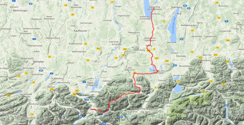
The route
Initially we planned to start in Herrsching. We picked Herrsching at the Ammersee, as this was the final stop of a local train line which directly connected us with Englschalking, where we spent the night. Also, since we were to end the route at a Lake, it seemed appropriate to start it at a lake as well. Starnberg would have been a likely alternative, but there we had already been on our last Transalp in 2015.
However, the evening before Martin got the idea of just cycling all the way to Herrsching. That’s about 45km. On top of the 110km that the stage would be. He got me hooked, and I improvised a transfer. Basically, we went out of Munich along the Isar until Thalkirchen and then headed West to Neuried. From there, we just headed South to Gautin and Hadorf (road construction works forced us to deviate via Buchendorf). Traffic was mild to non-existent, and completely disappeared in Hadorf when we turned West again to Unering. Now we only followed street signs to Herrsching and enjoyed a nice and speedy descent into the town. Views on the Alps appeared late, but the mild curves of Munich’s hills were a massive pleasure.
Next, we followed the Eastern shore of the lake, where a cycle path accompanies the road. The route will now always ascend, but ever so slightly, so that for the most part you don’t really notice it. Until Weilheim, we relied entirely on cycle pathes and cycling-friendly streets. Only for the last kilometer, we went on the B2 road, which can be busy at times, but was not at that day. Weilheim is beautiful, but maybe comes a bit too early for a break.
The subsequent stage-in-the-stage took us to Murnau.* It was maybe the highlight of the day. We had selected a route over small villages. South of Huglfing, we rode on a street dedicated to forest workers and cyclists, granting us amazing views over the German Alps as we got closer to Murnau.
(* From Murnau, you can also go South and get via Mittenwald to Seefeld and Innsbruck. That would lead on a more Eastern and more classic Transalp route, typically to continue via Reschenpass, Timmelsjoch, or Brenner.)


Murnau is a perfect setting for a lunch break. The pedestrian zone has a huge offer of different type of food stops (bakeries, cafes, ice cream places, traditional restaurants, even a pizzeria and a kebab shop, if you need), and the water from the fountains is nicely fresh and tasty. It’s also just plain beautiful. Finally, it has a train station. If the weather does not allow a full day, you can either stop here or start here.
Until here, the route worked great – better even than I anticipated. But then we had 15km that we felt to be less appealing. We needed to go West, so we took the St2062 to Bad Kohlgrub. It’s basically the only option. On OpenStreetMap, this one is classified with medium traffic, but we perceived the traffic to be a bit stronger than that. Since this is also the first time that the roads noticeably tilts upwards for quite a while, I can imagine more pleasant things. Thanks to a separate cycle path, it’s fine until Grafenaschau. From there, a cycle route goes parallel to the street, but this one runs over gravel, so you’re stuck to the street for about 10km into Bad Kohlgrub and Saulgrub. Really, it’s just a short bit, but the strong contrast with the rest of the route made it feel much longer than that.
From Bad Kohlgrub/Saulgrub, it’s all beautiful again thanks to nicely paved cycle pathes close to or right next to the main street. A bit later, Oberammergau offers another convenient spot for a Capuccino break. After Oberammergau, we stood West of the Ammer on a road that seems to be important only in Winter for accessing cross-country skiing tracks (the parking ticket machines in a completely remote area are testimony of that) in order to avoid the busy B23. At the end of this road, we turned right and then had a 15km climb up to the Ammersattel. Well, climb. The incline ranges from 1 to 3%, except for the final bit, when it goes up to 8-10% for about 500m of distance. The road goes through forest and is not the most exciting for sure, but on the other side of the climb, one reaches the stunning Plansee, which may well be one of the most beautiful mountain lakes I have found so far. By the way, meanwhile, we’re also in Austria.


There are some wild, rather steep spots to enter the lake along the street. Careful: the “beaches” are stony here. An alternative is a green, flat area at the end of the lake. It’s more busy there, obviously. Well, and then it’s just a downhill to Reutte.
In total, we are speaking about 155km and 1,750m of height difference from Munich – or 108km and 1,350m if Herrsching is the start. Both is quite a bit, but did not feel like that much. (Admittedly, we had tailwind for most of the way.) I really like about this route that it offers a gradual start to a Transalp adventure. Like a good aperetivo. It’s not all-in from the beginning, but it does already include a real pass, offers various occasions for a lake-swim, and attracts with great panoramic views.
Accomodation
We actually slept in Leschaschau, just outside of Reutte, in the Hotel Goldene Rose. The rooms are good, but the WiFi was mediocre. Breakfast was great instead. We also had dinner at the hotel. It’s decent. There’s nothing super special and exciting about this hotel, but also nothing negative to say. Rooms are nicely affordable and have good views and we found it to be silent.
In case of rain
Reutte has a train station, as have many cities along the way. One will need to change the train at least once, but there’s always an option.
Make it more or less challenging
From Murnau, one could first go South via Eschenlohe to Oberau. This adds a climb from Oberau to Ettal to get back towards the Ammersattel. There’s also a more hilly route from Weilheim to Murnau, which passes Eberfing, Obersöchering, and the Riedsee.
Conversely, a route running from Weilheim via Peißenberg to Füssen should be hilly, but have in total less elevation. However, I also think it’s much less interesting than the route we proposed.
