
This July, I crossed the Alps with a group of friends. We went from Munich to Como, so this was kind of like cycling home for me. The way we followed was maybe a bit unusual as compared to most Transalp routes that I have seen floating around, so I labeled it a bit encroachingly the Zweiradberge-Route – that’s the name of our Whatsapp group. I already gave a synopsis of the route some time ago. Now, stage by stage, I want to go a bit more in depth with the route.
And here are details on stage 2. Complete with a link to my Strava ride, a most insightful visualization of the route generated by Relive.cc, and the YouTube video that summarizes our experience.
Kaiserwetter […] ist eine umgangssprachliche Redensart und bedeutet “sonniges Wetter” bei tiefblauem, wolkenlosem Himmel. […] [L]aut Duden geht diese Redensart ursprünglich auf den meist strahlenden Sonnenschein am 18. August, dem Geburtstag Kaiser Franz Josephs I. von Österreich (1830–1916), zurück.
Kaiserwetter is a colloquial term and indicates “sunny weather” with deep-blue, cloudless sky. According to the Duden (German dictionary of reference), this proverb refers originally to the common sunshine weather on August 18, the birthday of Kaiser (emperor) Franz Joseph I. of Austria.
Route
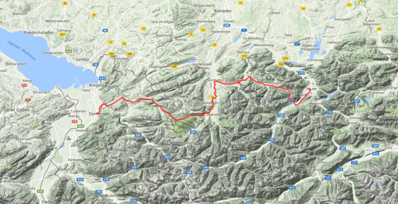
During planning, this was one of the most debated routes. The general idea was easy: From Reutte we wanted to get West all the way into the Rhein valley, because we wanted to cross Liechtenstein the day after. But there are many options. A quick overview:
(1) Just follow the Lech river. Heading South in the small village of Warth, one needs to cross the Flexenpass and then goes down via Bludenz to Feldkirch. As a side note, from the Lech valley, one has also several options to get back on a more Eastern route, most notably the Hahntennjoch.
(2) In Warth, one can also go further Northwest via the Hochtannbergpass. Turn West in Au and cross the Furkajoch to Feldkirch.
(3) Or one can go even more Northwest from Au and use the Bödele to get down to Dornbirn.
(4) The previous options all get rather lengthy and climbing-focused and some of them have a reputation to carry quite a bit of traffic. Since some of my companions could not cycle that much in preparation, we were searching for an easier route. So, initially I planned to cross the Tannheimer Tal from Weißenbach to Bad Hindelang and Sonthofen, and then to take the Riedbergpass in direct continuation. Afterwards, one also needs to cross the Alberschwende to get to Dornbirn or anywhere in the area of Bregenz, if not one takes a rather lengthy northern detour.
(5) However, at a closer look, the Riedbergpass is a nasty mate. Steep. Instead, another alternative is the Rohrmoossattel, which runs parallel to the Riedbergpass – just 10km more South. Just one of its advantages: It’s a toll street and hence almost entirely traffic free.


So that’s the option we picked, and it implied six climbs, of which the first three are the most well-known. First, the Gaichtpass from Weißenbach up to the Tannheimer Tal. That one is easy. We all were surprised by how fast it went by. There are some nice views back into the valley. Second, the Oberjoch coming from West, which is the easy side of this climb. It’s actually just a longer hill: 2km and 100 to 150m of height difference. The descent goes through a rather large number of hairpin turns, which makes for great riding fun. Third, the aforementioned Rohrmoossattel. There are a few steep but short bits (I remember three ramps), but it’s very mild for the rest. Just don’t forget to fill up water in Fischen or Oberstdorf.
The final three climbs consist of two hills (100m height difference each) and a longer ascent from the Lindenau bridge to Alberschwende. Of that last one, the first 500m are steep again, but then it flattens out.
Regarding traffic, we made two suboptimal choices. On the one hand, aside of going through Nesselwängle, we decided to cross the Tannheimer Tal mostly by staying on the main street through the valley. We did so to reduce the distance, to ease the navigation, and to avoid a few meters of climbing at the edges of the valley. However, between Grän and Schattwald, one should be able to avoid the main street on small ways paved with asphalt. On the other hand, the road from Hittisau via Lingenau to Alberschwende also carries quite a bit of traffic. If one is fine with riding 10km more and adding a few meters of climbing, there might be some alternatives.
Two highlights of this day I want to mention. We were completely in love with the ride from Sonthofen to Fischen. We had very clear weather, so could see the mountains behind Oberstdorf in all their beauty, but really… this was stunning. I also truly enjoyed the wide view that we had on the Lake of Konstanz during our final descent to Dornbirn.


Finally, while we slept in Dornbirn, we used the frequent commuter trains to get to Bregenz, to take a swim in the Lake of Konstanz, and to have dinner there. It’s a ten-minute train ride and that certainly pays off. Swimming is possible just 100m North of the final stop of this commuter train.
This route sums up to 115km and 1,450m of climbing. In principle very doable, but in the second half, there are no flat bits anymore – it’s either up or down. That felt a bit challenging for some, though the temperatures might have played a role as well. It’s climbing now. Still rather easy, but not nothing either.
Accommodation
We found sleeping in Dornbirn to be a good compromise between being able to access the lake and not having to cycle more kilometers the next day. The trains are convenient. In order to facilitate this, we booked rooms in the Viennahouse Martinspark-Hotel, which is a 7min walk from the train station. It’s a business hotel, so all rooms are two-bed rooms. Breakfast was very satisfying, but not filled up very fast, but the hotel offered strong WiFi and a locked bike storage in the underground parking garage.
In case of rain
There are no trains running parallel to the route, but at the start in Reutte and half-way in Sonthofen, Fischen, and Oberstdorf, one can use trains to get enough back into Germany to find a connecting train to Lindau and Bregenz.
Make it more or less challenging
For this section, I just refer to what I have already said at the beginning of the route description. There are plenty of options to go for a more challenging ride. To make it less challenging, I can see a slightly longer route that goes from Sonthofen towards Immenstadt and then heads to Dornbirn/Bregenz via Oberstaufen.
