
Bozen is surrounded by mountains, so it’s difficult to find the local mountain. The Rittner Horn is a likely candidate, as it’s the best accessible peak. There is stuff to do all year around. Most importantly: it is topographically rather isolated, i.e. in almost any directions higher mountains are on the other side of another valley. These valleys are wide enough, so that then from certain spots there is a 360° panorama that lets you learn the shapes of mountains as far away as 80km. On a good day, of course, when the sky is clear.
And, oh boy, did we catch a good day!
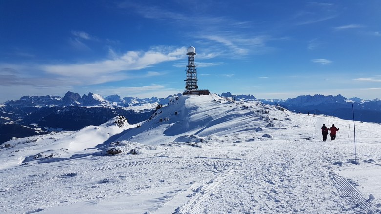
The peak of the mountain reaches 2,200m and a bit. It looks more like a curved hill of 400m height only, however. Minus the trees. Of course, it’s not flat, but the hike up to the peak is not challenging in any means. You will not ever need your hands. You will not stop from exhaustion if you maintain your rhythm. You will not have to think about losing your grip and falling down a slope. Very likely you could hike up with a child cart – but I’m stretching it here, as I’ve seen the peak only in winter.
Exposed mountains tend to be icy and cold in winter, but remember that this is Südtirol. There is some wind due to altitude, but it’s mostly pleasant and just enough to let them have fun with their snow-kites. There is a lot of sun. Unless when Siberia sends its cold air over, it usually feels warmer than it objectively is. Consequently, it certainly is not the icy desert that I’ve found in the Czech Republic a few years back. Just next: the Czech Republic on the left side, and Südtirol on the right side.


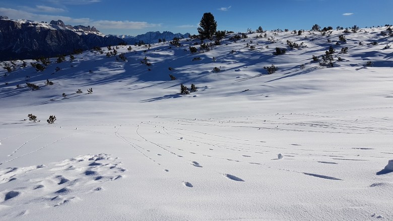
Still, there is some guarantee to find snow for a long part of the season. Fortunately, not all of the mountain is a skiing slope. Some is – and it’s a nice one for beginners. Or if you’re a bit advanced and just want a relaxing day. Certainly it’s much less crowded then at the usual places in Südtirol. You can also take a sled. Or bring cross-country ski along and go for a long track (no loop: way and back is the same) over this hilly surface. And beyond that, just be creative.
We hiked for three hours
For us, it was the second day of my Mum’s first visit to Südtirol since the girl moved. We arrived at about 10.30 and effectively reached the top of the cable car at 11.00. Then, it took us about 60min to get to the peak. And another 15min to just enjoy the panorama.


On the graph below, we started at the lower end where the Ritten marker is. (There is also an official map.) Then we walked up the left side. The peak is at the marker for the Corno del Renon – that’s just the Italian name of the Rittner Horn. The marker of the Feltuner Hütte in the center seems a bit inaccurate – it’s closer to the central point. Anyways, the third green marker (here labeled ‘Recreatiecentrum’ because my GoogleMaps operates in Dutch) indicates the position of a panorama platform. I’m going to mention that one again in a bit. You can access my data on Strava or download the track from a professional website. Of course, if you go for Strava and have a Strava account yourself: I don’t mind your kudos.
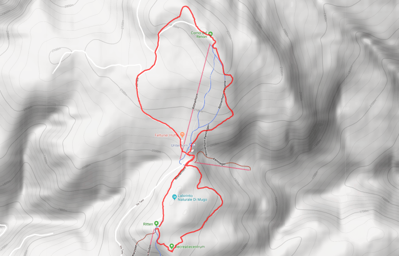
The way back consists of two stages. First, it’s a simple decent (30min) back to beginning of the loop. From there, it’s a 20min walk straight to the cable car – the same way you came. Or you turn left and walk around the small side peak of the Rittner Horn (the Schwarzseespitze – Cima Lago Nero) and continue to follow the premium hike. This took us 45min – so about twice the time. It’s worth it, if you have the time and energy. This part of the hike is much more quiet and the landscape changes a bit: There are some isolated trees, and there are a number of bushes. Traces of animals and self-moving snowballs (yes, that’s a thing) rather than of skiers leave marks in the snow.
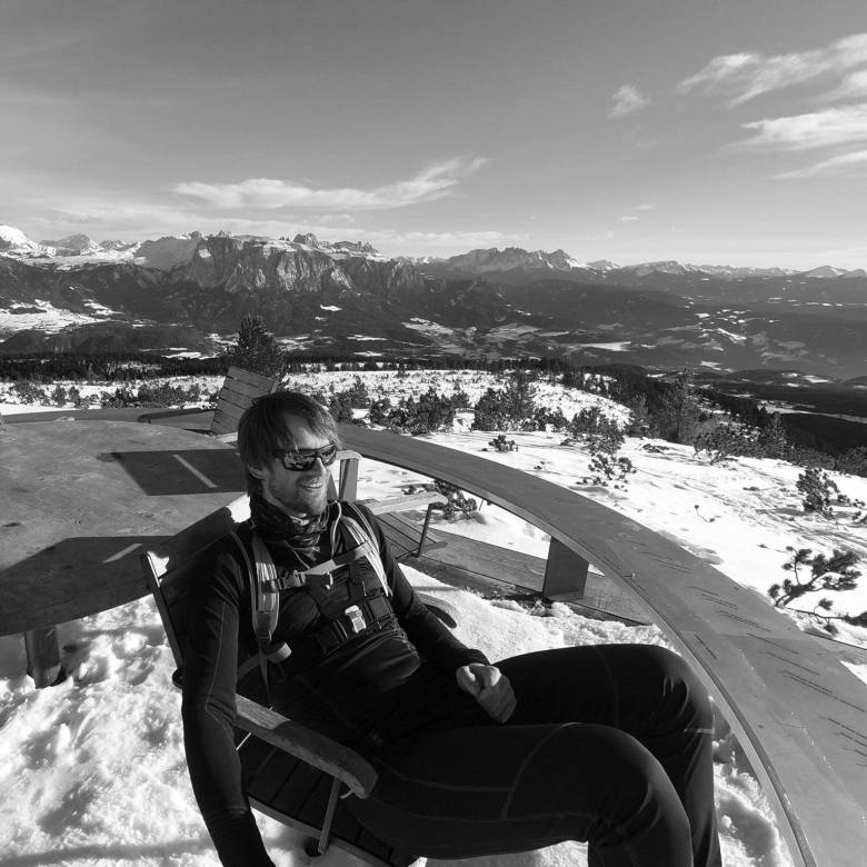
Towards the very end of it – and you reach this within five minutes also from the side of the cable car – comes the very highlight. They have built a wooden platform that supposedly gives you a 360° view over the Italian Alps and Südtirol. It’s more like 300°, because now the Ritten itself is in the way on one side. They have added a labeled profile. If you are nerdy enough, you could spend hours here and learn the names of all the peaks you see based on their shape. I started. The girl is not that nerdy: she saved me from going all the way through with it. My nerdy Mum had the smarter approach: she took photos for some at-home exercise. I also sat down for a moment, but unfortunately no one served Strudel up there.
Sixty plus fifteen plus thirty plus fortyfive sum up to a total hike time of 150min. Add to this a bit more than half an hour of break time on the peak. After about three hours, we had reached back the cable car. For some, this hike might be too short. If that’s the case, just have a look at the earth pyramids on the lower parts of the Ritten. Or spend more time sitting in the sun. Or don’t use the cable car to transfer between the valley station of the cable car in Pemmern and the official beginning of the premium hike: Hike up, or down, or up and down. Or rent a sled in Pemmern and kick yourself with some endorphins.
While your eyes eat nature, eat Südtirol with your teeth
Up there, we found a small place for food: the Schofstoll. My Mum had the idea to sit outside. The sun was admittedly inviting; I only was a bit worried about the windchill effect over time. We were prepared for colder temperatures, however, and then this brought us through the break – even though service was a bit very unorganized and a bit slow. (Advice: when you take orders, write down something like a number of the table, so you know where you have to bring the food when it’s ready.)
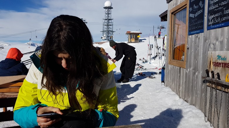
Inside, there are only four tables and not much space. The Feltuner Hütte is a much bigger place to eat at the central place of the skiing slope, however. The hike passes by both on the way up and the way down. Going down, it’s 30min. The panorama is similar, since the terrace on the peak looks in the same direction.
Accessibility is a breeze, but be careful with summer tires
In fact, it would be possible to get there entirely with public transportation: take the bus 165 from Bozen to Klobenstein. (If you want to do that more unique: take the cable car from Bozen to Oberbozen and then jump on the historic light rail between Oberbozen and Klobenstein.) Then take the bus 166 from Klobenstein to Pemmern.
If you drive, there’s a big parking right at the cable car. However, half of the parking consists of a slope. We figured that this made it tricky for cars to get out of the parking again. At the parking, snow had already melted. There was a lot of humidity in the soil underneath the grass. This humidity was solid in the morning (due to the cold of the night). As sun warmed up the surface, the grass turned into a muddy battleground. And that’s just as slippery as ice if you have the wrong tires.
I was lucky. On one of the two ramps, I didn’t get up. IT looked like a number of people had tried and failed here. I rolled down backwards to the flat end of the parking. Then I steered to the other ramp, which had a tiny bit more shadow. I maintained enough momentum to keep the tires rolling. This is an exercise that you want to do in the first or at most in the second gear. I reached the top. Left and right I saw a guy each busy putting snow chains on their wheels. Or, more correctly: mud chains.
Hence, if you can, park on the flat top part of the parking. Chances are you can’t, because that will fill up a bit more early and they assign you to a parking anyways. And don’t worry anyways when it’s cold enough or dry enough.
