
This July, I crossed the Alps with a group of friends. We went from Munich to Como, so this was kind of like cycling home for me. The way we followed was maybe a bit unusual as compared to most Transalp routes that I have seen floating around, so I labeled it a bit encroachingly the Zweiradberge-Route – that’s the name of our Whatsapp group. I already gave a synopsis of the route some time ago. Now, stage by stage, I want to go a bit more in depth with the route.
And here are details on stage 6. Complete with a link to my Strava ride, a most insightful visualization of the route generated by Relive.cc, and the YouTube video that summarizes our experience.
Route
A flat stage. That was never meant to be a flat stage. This was rather a last-minute change to the route that I pushed on the guys just one week before departure. I had just done two last tests of my own shape and was wondering, given my feeling, if the guys would manage yet another hard day. We had originally thought to continue stage 5 until Poschiavo, i.e. climbing up the first third of the Bernina-Pass. Stage 6 then would have led us up all the way to the Bernina and from there through the Engadin and down the Maloja to Chiavenna, with a final flat bit to the lake and a stay-over in Colico. Oh, it would have guaranteed a fantastic landscape. But in this area, that’s true everywhere, and you can’t have everything. It’s a reason to meet up again next year.
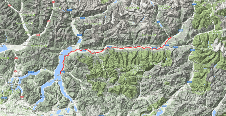
Now, what we did was the simplest of all possibilities: Follow the Sentiero di Valtellina from Tirano to Colico, where we would reach the lake. Ignore Sondrio, but stop in Morbegno for lunch. I had been there just a week before and thought it was rather boring. Morbegno was new to me, too, was not much less boring, but gave me the feeling that there is a massive potential in that place, since it has a well-maintained historic center with some cute spots. It just needs… more tourists and more open shops.


Between Tirano and Colico, the Sentiero di Valtellina is of changing quality. The first bit, from Tirano to Tresenda, is fine. Then it’s less good, but still okay until about Carolo – the landscape compensates for much of the broken asphalt. There is one village along the way where the pavement consists of cobbles. Between Carolo and Morbegno, I would advise to take the normal road to the South of the river Adda. There is not much traffic, which instead uses the SS38 North of the river, but in that section the Sentiero di Valtellina has many episodes with broken asphalt, open roots, or just generally a rough surface – it definitely needs repair. The Southern road is called SP19 until Busteggia, but then is a small, unclassified road until Torchione, where the SP16 appears.


At the end of the SP16, there is no alternative to the busy main road in order to cross the river that comes out of the Valle di Tartano. However, the main road has wide shoulders, so that’s actually safe. In order to get back on the Sentiero di Valtellina, the route should take the next option to get off to the right. Instead, since we wanted to get into Morbegno, we turned left at the first opportunity. From Morbegno, we then got back on the Sentiero di Valtellina, which in that section is again of great quality. Just before Colico, the asphalt ends at a bridge.
So, there is the lake. Naturally this is a signal to take out the swimming gear for a quick dive. Just I have to say… while the beach is not too stony, the water quality of Lago di Como feels nicer elsewhere.
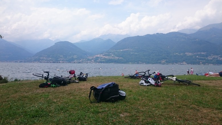
From Colico, the route is straightforward, as the road along the Eastern shore is more or less the only choice. It goes a tiny bit up and down, but not too much, and between Bellano and Varenna there is a tunnel. Not long, but long enough to think about light. In Varenna itself, we stopped the ride. It’s a place with a great atmosphere. During daytime already not as overcrowded as Bellagio, but with a very cute historic center and a nice walk along the lake.
In fact, if you just walk as close to the lake as possible, even beyond the port and through a silent path in what seems to be the quiet, cute backyard of the town, you will inevitably find a small beach. (Hint: you’ve reached it when you see the private bridge from a hotel to its terrace crossing the path. It’s about 10min from the ferry port or 5min from the old fishermen’s harbor.) This beach is rocky, but the panorama is one of the best of the entire lake. It’s also not very well-known, hence there are few people. Trivia: Sometimes, I have seen a guy there fishing for a local restaurant.
There’s really not much challenge in this route. It’s about 95km and allegedly 300 to 600m elevation. (But I think the 600m that my device tracked were grossly off in this case. It’s really flat with a few small hills that are not big enough to be mentioned individually.)
Accommodation
Well, it depends a bit on what you have planned for the last day. We wanted a final loop, starting from Bellagio. So we already took the ferry to Bellagio. But it’s just as convenient to stay in Varenna. We had chosen the Hotel Centrale Bellagio. The rooms are nice, but those to the garden can be a bit noisy, the guys said. Those on the opposite side instead even have a tiny bit of lake-view. There is no rain-safe bike parking (and that evening it rained hard), as the bikes should be left in the garden, but one cannot see inside the garden from outside, and it’s locked over night.
By the way: Before we decided to change the route, we had planned to stay in Colico. There, we had booked the Hotel Lago di Como. That one had assured us that they have a safe place to lock away the bikes.
In case of rain
Super easy. You take the train from Tirano which stops at various locations, among them Sondrio, Morbegno, Colico, Bellano, and Varenna.
Make it more or less challenging
Plenty of options to make it more challenging. For instance, you could actually cycle up the Bernina-Pass from Tirano and do all the loop over the Engadin and Chiavenna. This will add about 30 to 40km and 1500m of climbing, all of which comes at the beginning. Much of the Bernina is steep.
Two options appear later, in Dervio and Bellano, i.e. already at the lake. In Dervio, a street leads up to Premana. The first part of that street is also the first half of the ascent to the Monte Croce di Muggio (1799m), which seems to be a popular climb in the area. On the other side, the street leads back to the lake at Bellano – either hilly via Narro or gradually falling via Taceno. Coming up from Bellano instead, in Taceno starts the panoramic SP65 over the Passo Agueglio, which then finishes in Varenna.
The only idea that I have to make it less challenging is to take the train up the Bernina. Why is that less challenging? Well, because then it’s not 100km flat, but 110km during which you will need to loose 2,000m of altitude.
