This year, the season never seems to end. The weather forecasts 25 degrees for the upcoming weekend. If there is time, I intend to add a 125km ride from Voghera over the Passo Penice to Piacenza.* But ideas for bike holidays in 2018 are already circulating in my head.
One of my comrades from this year has indicated that he might prefer a bike holiday on Mallorca. I personally disagree with this idea. The Balearic islands in July can and will see temperatures around 35 degrees. At least there’s no rain, but constant sun might be a false friend. They have little shadow. There is not enough elevation to get into cooler zones. I know this shit from cycling around Milan. There is a reason why Mallorca’s races are in fall and spring, and while people mostly use it as an early-season training camp or as a place to extend their season into fall. I also don’t really like Mallorca, and if this Island cycling becomes a thing, might propose an alternative trip to Corsica instead. There at least you get to meaningful elevation. Maybe even a combined trip to Corsica and Sardinia. I’ll cover that in a future post.
Fittingly, the Mallorca idea popped up the very same day I had started exploring a new Transalp route. France is another option. None of us has ever visited the iconic mountains of the Tour de France. Many of those are very close to each other. We could drop the concept of stages and instead take a more permanent location. The guys might be happy about not having to carry their backpacks. Flying in is easy, and road bike rentals should be available in the area as well. It’s the next thing to explore (and will end up in a future post as well), but I still was pulled back into the Central Alps first, when I had an idea.
Originally, my Transalp ideas had been centered around the Timmelsjoch (which I did in 2011 as the highlight of my first Transalp), Lago di Molveno (also on my route in 2011), the Umbrail (the just slightly lower twin brother of the Stelvio, which is only fully paved since five years now), the Gavia (in the opposite direction to my trip from 2015), and the stunning cycle path at Lago d’Iseo on the old trajectory of the coastal road, including all the short tunnels. It would be a beautiful route by itself, but if I collapsed it into a one-week trip, stages were to exceed the difficulty threshold for the guys. Also, I basically would ride 100% on roads I’ve done already, and also the guys were going to cover well-known areas very similar to those from our last two adventures. They’d just look at the same mountains from another angle.
Then I remembered a bike video that I had watched earlier this year. (This guy cycled Munich to Venice in one go. Read: 500km in 24 hours.) And a thread on Germany’s leading road bike forum, rennrad-news.de, in which another guy presented his ride from Munich to Venice. I recognized that there is apparently a stunning bike route coming down from the Dolomites and then passing Belluno and Feltre on the way to Venice. I had finished in Venice in 2011, coming from Verona. We had passed the Dolomites in one day in 2015. Both sources above first cross the main ridge of the Alps via the Brenner. I was wondering how that could play out with a more Eastern route right from the start.
Turns out: Incredibly well.
The route
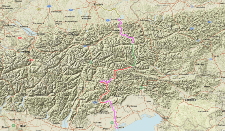
The following is just a short list of the individual stages, links to gpsies.com included. The route has a good mix of fairly easy and rather challenging stages. Three stages have more than 2000m of elevation, but one of those three has a climbing/descending ratio of much less than 1. (That means that there’s some climbing, but gpsies.com will add climbing meters also on a long gradual descent. Any GPS recording device in reality will not capture more than 2000m of elevation.) There are never more than two difficult stages in a row. Big and beautiful lakes could offer refreshment on various stages. Cities are large enough to find easy accomodation. Only three stages reach 110km, and two of them are flat.
Stage 1: Munich – Prien am Chiemsee | 100km distance | 1000m altitude gain
Stage 2: Prien am Chiemsee – Zell am See | 115km | 1600mm
Stage 3: Zell am See – Lienz | 90km | 2600m
Stage 4: Lienz – Cortina d’Ampezzo | 80km | 1500m
Stage 5: Cortina d’Ampezzo – Canazei | 70km | 2500m
Stage 6: Canazei – Feltre | 120km | 2600m
Stage 7: Feltre – Venice | 115km | 1200m
What makes it special
One of the most special moments will come on the last day. The last 3km of the route run over the dam from Mestre to Venice. This promises a unique finishing experience. It works so great as a true finish because after crossing that dam, there really is no way to continue other than to turn around and cycle back. And there’s no need to cycle back, because the train station is right there on the island. The downside: It’s objectively not the prettiest panorama ever. Half of the effect comes from imagination.

That photo is from 2011. Sorry for the shakiness. Looking back at it, I notice how cameras have evolved. But also that bike lane was recently renovated.
There are some other cool highlights along the way. The first two days are for warming up. Both stages end at a lake, which is usually the best spot to find them. It’s a gentle landscape, quite some hills, a minor pass, nothing that will be really challenging. It should not be. Day three crosses the Großglockner. At 2500m, it’s Austria’s highest pass. The Northern ramp is more difficult (bit shorter, bit steeper) than the Stelvio. Based on pure statistics, it would challenge more than the Mortirolo, the Gavia, the Kronplatz, and the Monte Zoncolan, which are considered the toughest mountains of the Central Alps. These statistics might be a bit misleading, as all of these are maybe not as long, but even steeper. Nonetheless: The Großglockner is is a beast.
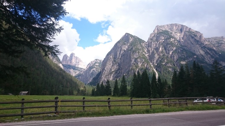
The day after is much less challenging. The street always rises gently. For just less than ten kilometers, slopes become a bit more meaningful, but nothing as compared to the day before. The reward is the spectacular panorama on the Tre Cime from the Lago di Misurina. (The adjunct mountains feature on the next photo. We took this one in 2015.) It’s the opening of three days through the Dolomites. Passo di Giau is another wet dream of cyclists.
We would ride it on one stage with the no less significant Passo Pordoi, which is maybe the most famous of the four summits that go around the Sella mountains. That stage is short, but full of climbing. The Passo Fedaia on day 6 would lead us through an amazing narrow and deep canyon on the downhill (Serrai de Sottoguda), where explosives carved the street out of the rocks.
Credits for this shot (and the photoshopping) go to the folks behind the Baita Dovich hut, a mountain refuge close to the canyon.
And later that day, on our way out of the Dolomites to Feltre, a very scenic bike path would let us bypass some tunnels in another narrow valley. This is the day that looks more difficult on paper than what it is in real life, as the software accumulates some elevation gain also on the long descent.
For the final day, one last and mild mountain would give us a final descent over another engineering miracle. On that mountain, the road is basically stacked vertical, and the turns need to go through little tunnels because there was not enough space to build them open air.

This photo I’ve taken from Wikipedia. Some more here. And here with some history. It actually took them one-hundred days to build it. One hundred. Days. During the first World War.
And I think I even found a rather entertaining route from the Alps via Treviso to Venice, avoiding the main streets, and giving us some views back to the mountains (if visibility allows for it). With Venice being a major city, that flat bit also gets some meaning to it.
It could be a great trip. It’s an unconventional route in that it completely avoids Südtirol and only touches Trentino. That’s almost bizarre. After all, it will be the first summer in which we even have a house in Bozen. But except for 30km, it would be a completely new route for all of us. And a more challenging alternative to a long-distance cycle route that has been developed for recreational cyclists.
So, let’s see what the guys say.
*Since I mentioned it. At 1140m, the Passo Penice is one of the highest passes in the Northern Appenine Mountains. The peak of Monte Penice is visible from Milan. Starting in Voghera at 90m above sea level, it’s about 55km of climbing till the top. Never very steep, but never flat either. I will approach it from the Passo del Brallo, which is 10km to the South. The two are connected via a mostly flat panoramic road that also covers a third pass in between those two. My ride also includes a bit of the beautiful cycle path on the former train track of the Voghera – Varzi line, passes the scenic village of Varzi before the Penice, and its counterpart Bobbio on the other side. I will then follow the Trebbia on my way to Piacenza, but will avoid the main road. The old road through the villages is often available, too. Might add a few meters of elevation here and there, but should be more quiet.
