
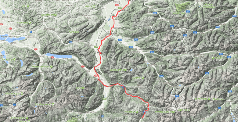
This July, I crossed the Alps with a group of friends. We went from Munich to Como, so this was kind of like cycling home for me. The way we followed was maybe a bit unusual as compared to most Transalp routes that I have seen floating around, so I labeled it a bit encroachingly the Zweiradberge-Route – that’s the name of our Whatsapp group. I already gave a synopsis of the route some time ago. Now, stage by stage, I want to go a bit more in depth with the route.
And here are details on stage 3. Complete with a link to my Strava ride, a most insightful visualization of the route generated by Relive.cc, and the YouTube video that summarizes our experience.
Route
Among the most difficult rides I can imagine are those days when it’s always just going up and you know there is not even a descent at the end to reward you for the effort. Well then… that’s what we had ahead of us for day 3. In this case, it was actually much better than the profile made it look like. Also, for the third day in a row we benefited of a rather unusual tailwind.
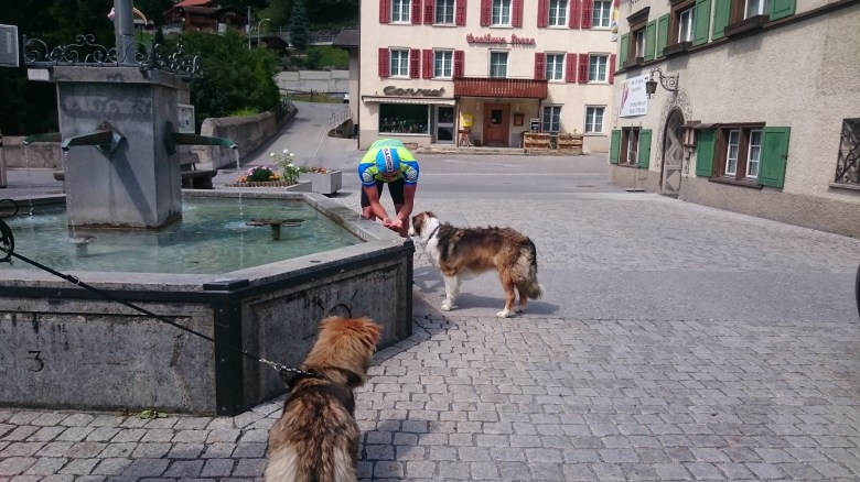
We had some initial kilometers left in Austria. That was still enough to take a first Capuccino break in Feldkirch. It’s only 30km into the stage, but then prices rise sharply. In fact, I wanted a bit of ice cream in Vaduz and paid 3,50 EUR for one (!) scoop. It was good ice cream, and it helped a lot to cool down – but for really a massive price.


I had been in Liechtenstein some 25 years ago as a kid. It was a rainy day back then and I remember that I was not too impressed with Vaduz. I thought it was the rain. Maybe it was not only the rain. The countryside around is amazing, but the city itself appeared a bit boring to me. If I were to go again, I’d just leave it aside and continue the ride. The same in Switzerland as we reached Bad Ragaz. Was kind of cute, and we thought to have a stop for a piece of cake, but it was also vividly lifeless (this contradiction intended). It was a Tuesday afternoon. Italian-style lunch break? But the same holds also for the traffic on the Rhein’s bike pathes. We expected many tourists and instead found ourselves to be alone.
It’s here where I realized how underrated the Zweiradberge-Route might be. Getting out of Dornbirn meant to cycle along a busy road for some time. But we had separate bike path, and nonetheless fantastic views. Later, we took a deliberate detour to get away from that street. After Dornbirn, we just followed agricultural roads to Vaduz, and then we finally reached the asphalted bike path on the dike of the Rhein. Just following the signs, we ultimately got to Landquart. Easy, enjoyable – ingredients for a lazy day.


Here we did split, having already covered about 70 kilometers. Our two weakest group members opted for plan B, which meant to just go for another 15km along the Rhein to Chur*. From Landquart onwards, bike lanes get a bit more sparse, but traffic was low. Us other three turned towards East and entered the Prättigau. I had read very ambiguous descriptions about: Nice scenery, but high traffic, which however should mostly go via the separate main road that we as cyclists are not even allowed to take.
(* Chur could also be the choice for more challenging and/or more lengthy options. From Chur, one can directly ascend to Lenzerheide and then cycle over the Albula-Pass the next day instead of the Flüela-Pass, which we took. Alternatively, the Rhein valley continues to the short Northern ramps of the Splügenpass and the San Bernardino. The latter two directly lead down to the Lombardian lakes, which we would reach only a few days later.)
By July 2017, the Prättigau’s main road has certainly taken up virtually all traffic. The alternative road over the villages is essentially a bike lane – and a bike lane indeed helps to pass the narrow canyon between Jenaz and Küblis. The whole thing starts very easy with only two short steeper sections ahead of Küblis. However, getting out of Küblis involves a 1km ramp with gradients certainly above 10%. From Küblis, you see the church tower of Saas and just hope you won’t have to get up all the way there. But you have to. Then from Saas you look back and are a bit in disbelief about what just happened.
There’s a fountain and a super market in the center of Küblis. I highly recommend to make us of that spot to refill bottles and bellies.
After that ramp, things get easy again until Klosters, but navigating got a bit more tricky. Soon after Saas, we reached a roundabout at which we crossed the main road. We followed the bike route sign even though it disappointingly meant to loose a few meters of height. Hold yourself on the left, and make sure not to miss the left-turn underneath the main road’s bridge. Note: This turn leads into a very short but very steep ramp. On OpenStreetMap, this path is mapped as gravel, but it’s all asphalt.
Since quite a while, we could already see the Wolfgangpass in the mountains behind Klosters. For us, this was a bit worrysome, because those mountains were decorated in clouds that could easily have turned into thunderstorms. They didn’t until they had moved on, so the only thunder we felt in our legs as soon as the road kicked up after Klosters. It’s now 6.5km and still 500m of climbing. All of a sudden there’s also a bit of traffic. Not too much, but in stark contrast with the situation before. There are not many views anymore until the top, but at least quite a bit of shadow.
We had the, ehm, pleasure of a hot day. – Well, I did not find it so hot compared to Milan, but the guys complained. – So we actually had the real pleasure of being warm enough to completely ignore the water temperature and jump into the lake of Davos. We later figured that the water had allegedly 18 degrees. It was freaking cold. But hey… don’t they do ice bathes at the Tour de France on a regular basis?

My verdict on this stage is very positive. I had been much in doubt about the Prättigau. I would agree with others that the Wolfgang-Pass is a necessity for the transit, but the Prättigau itself was a pleasant surprise. The interventions done on the main road (building tunnels to bypass all villages) are a great (yet costly) example of how a landscape that has lost its appeal to the traffic that it once attracted can re-gain much of that appeal.
And in a way: This is maybe the core piece of the Zweiradberge-Route, as it’s a crucial link to combine elements of a Western Transalp through Switzerland and a more Eastern Transalp through Tirol and Südtirol.
Accommodation
In this case, I want to emphasize the quality of our hotel. At Hotel Edelweiß in Davos we not only found very affordable accommodation of very nice quality (the price level was European Union, not Switzerland), but also very great service (I’m in disbelief that it has only two stars). The Hotel crew took our dirty laundry and gave it a wash, so that by the next morning everything was dry and clean again. Very uncomplicated and for free. Plus, the bike garage had tools, pump, and proper bike stands.
In case of rain
Trains go from Dornbirn to Landquart and Chur (maybe they require a change) and from Landquart and Chur to Davos (again, maybe they require a change). From Landquart/Chur, trains are operated by the Rhätische Bahn, which is expensive. Our two mates who took the train from Chur to Davos paid 51 CHF each, bike included.
Make it more or less challenging
I already mentioned before that Chur is not only the easy alternative in combination with trains, but that it can be the basis of more challenging options. One option that still maintains the spirit of the Zweiradberge-Route involves to finish the day in Lenzerheide rather than in Davos. In that case, the Prättigau and Wolfgangpass are replaced with the climb to Lenzerheide – which has a similar reputation in terms of traffic. The real motivation for this alternative is the Albulapass, which would then be the more logical choice the next day as compared with the Flüelapass. However, the Albulapass is much more difficult and it would also stretch day 4 from 85km to 120km.
Other than just going straight to Chur instead of cycling through the Prättigau, I don’t see options to make it less challenging. What is less challenging than essentially flat?
